Getting Started
Index
NYC Neighborhoods
Manhattan
Brooklyn
Queens
Bronx
Staten Island
NYC Icons
Chrysler Building
Flatiron Building
Empire State Building
Safe NYC
NYPD
FDNY
NYC Weather
NYC Climate
NYC Weather Forecast
Winter Season
Spring Season
Summer Season
Fall Season
NYC History & Politics
New York City History
Tammany Hall and Politics
New York City Politicians
New York City Personalities
Culture of Gotham City
Culture of the city
Cultural diversity
City in popular culture
|
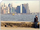
Upper New York Bay, sometimes called Upper New York Harbor or the Upper Bay, is the northern area of New York Harbor inside The Narrows. It is enclosed by Manhattan, Long Island, mainland New Jersey and Staten Island.
It is fed by the waters of the Hudson River (historically called the North River as it passes Manhattan), as well as the Gowanus Canal. It is connected to Lower New York Bay by the Narrows, to Newark Bay by the Kill Van Kull, and to Long Island Sound by the East River, which despite the name, is actually a tidal strait.
It provides the main passage for the waters of the Hudson River as it empties through the Narrows. The channel of the Hudson as it passes through the harbor is called the Anchorage Channel and is approximately 50 feet deep in the mid point of the harbor.
It contains several islands including Governors Island, near the mouth of the East River, as well Ellis Island, Liberty Island, and Robbins Reef which are supported by a large underwater reef on the New Jersey side of the harbor. The reef was historically one of the largest oyster beds in the world and provided a staple for the diet of all classes of citizens of New York City until the end of the 19th century, when the beds succumbed to pollution.
Historically it has played an extremely important role in the commerce of New York City. Entering the Upper Bay by a passenger ship provides for the first glimpse of the Statue of Liberty and became the hallmark image representing the immigrant experience during the late 19th and early 20th century.
Since the 1950s, container ship traffic has been primarily routed through the Kill Van Kull to Port Newark-Elizabeth Marine Terminal, where it is consolidated for easier automated transfer to land conveyance. As a consequence, the waterfront industries of the Upper Bay experienced a decline leading to diverse plans for revitalization. In recent years, it has become a popular site for recreation sailing and kayaking.
The harbor is traversed by the Staten Island Ferry, which runs between Whitehall Street at the southernmost tip of Manhattan near Battery Park (South Ferry) and St. George Ferry Terminal on Richmond Terrace in Staten Island near Richmond County Borough Hall and Richmond County Supreme Court.
A common misconception holds that the Upper Bay is devoid of marine life. It actually supports a very diverse population of marine species and recreation fishing, most commonly for striped bass.
|
New York City Search
Quick NYC
|


 New York Weather Forecast