Ward's Island, Manhattan, New York City
|
Getting Started
Index
NYC Neighborhoods
Manhattan
Brooklyn
Queens
Bronx
Staten Island
NYC Icons
Chrysler Building
Flatiron Building
Empire State Building
Safe NYC
NYPD
FDNY
NYC Weather
NYC Climate
NYC Weather Forecast
Winter Season
Spring Season
Summer Season
Fall Season
NYC History & Politics
New York City History
Tammany Hall and Politics
New York City Politicians
New York City Personalities
Culture of Gotham City
Culture of the city
Cultural diversity
City in popular culture
|
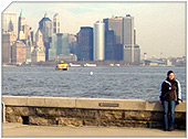
Ward's Island is situated in the East River in New York City. Administratively it is part of the borough of Manhattan. It is bridged by rail to the borough of Queens by the Hell Gate Bridge and it is joined to Randall's Island to the north by landfill. The two Islands together are run by the Randall's Island Sports Foundation under a partnership agreement with the New York City Department of Parks. Together, the two islands form New York County's Census Tract 240, which had a total population of 1,386 living on 2.2 km˛ of land area, according to the United States Census, 2000.
The viaducts leading to the Triborough and Hell Gate bridges pass overhead. Vehicular access is by road from Randall's Island, while a narrow pedestrian bridge, Ward's Island Bridge, links the island to the east side of Manhattan in Harlem.
The island is home to several public facilities, including Manhattan Psychiatric Center, Kirby Forensic Psychiatric Center (which serves the criminally insane), and a sewage treatment plant. It is also home to Ward's Island Park which offers stunning views, athletic fields, and picnic grounds.
History
At the time of its appropriation from New York's native inhabitants to the Dutch settlers in 1637, the island was known as "Tenkenas" which translated to "Wild Lands."
Later, the island's name changed several times. At times it was known as "Buchanan's Island" and "Great Barn Island," both of which were likely corruptions of the surname "Barendt," the name of an early owner.
During the Revolutionary War the island served as a military post for the British military.
After the war ended, Jaspar Ward and Bartholomew Ward took ownership of the island that later carried their surname. Although a small population had lived on the island since as early as the 17th century, the Ward brothers developed the island more heavily by building a cotton mill and building the first bridge to cross the East River in 1807, connecting the island with Manhattan at 114th Street.
The bridge, paid for by Bartholomew Ward and Philip Milledolar, was a wooden drawbridge. The bridge lasted until 1821, when it was destroyed in a storm.
After the bridge was destroyed, the island was largely abandoned until 1840, when the island was transformed into a dumping ground for everything unwanted in New York City. Between 1840 and 1930 the island was used for:
Burial of hundreds of thousands of bodies relocated from the Madison Square and Bryant Park graveyards.
The State Emigrant Refuge, a hospital for sick and destitute immigrants, opened in 1847, the biggest hospital complex in the world during the 1850s.
The New York City Asylum for the Insane, opened around 1863.
An immigration station from 1860 until the 1892 opening of Ellis Island.
Manhattan State Hospital, operated by the New York State Department of Mental Hygiene when it took over the immigration and asylum buildings in 1899. With 4,400 patients, it was the largest psychiatric institution in the world. It later became the Manhattan Psychiatric Center
Ward's Island began to change when the 1930 Metropolitan Conference of Parks recommended transforming Randall's and Ward's Islands into recreational parks. Robert Moses (1888-1981), Parks Commissioner in 1934, announced the plans for developing Ward's Island. The city would connect it to Randall's Island just to the north and it would be cleared for playing fields and promenades.
The creation of the park was followed by the development of the Triborough Bridge, starting in 1936 and lasting seven years, and the building of the Ward's Island Water Pollution Control Plant, which was built in 1937 and occupies nearly one quarter of the island.
The current pedestrian bridge connecting the island to Manhattan was built in 1951. It was designed to give access to Ward Island Park to East Harlem, which has few public green spaces.
|
New York City Search
Quick NYC
|
|
|
 How safe is New York City?
 Contrary to popular belief, the City consistantly ranks in the top ten safest large cities in the United States. The NYPD is the largest municipal police force in the world and has it's own Movie/TV Unit. |

New York has a humid continental climate resulting from prevailing wind patterns that bring cool air from the interior of the North American continent. New York winters are typically cold with moderate snowfall.  New York Weather Forecast New York Weather Forecast |

New York's two key demographic features are its density and diversity. The New York City metropolitan area is home to the largest Jewish community outside Israel. It is also home to nearly a quarter of the nation's South Asians, and the largest African American community of any city in the country.  Ethnic composition Ethnic composition |

New York Newspapers
 
|


 New York Weather Forecast
 Ethnic composition


